

![]() Intermediate
Intermediate
3 Miles
Overview
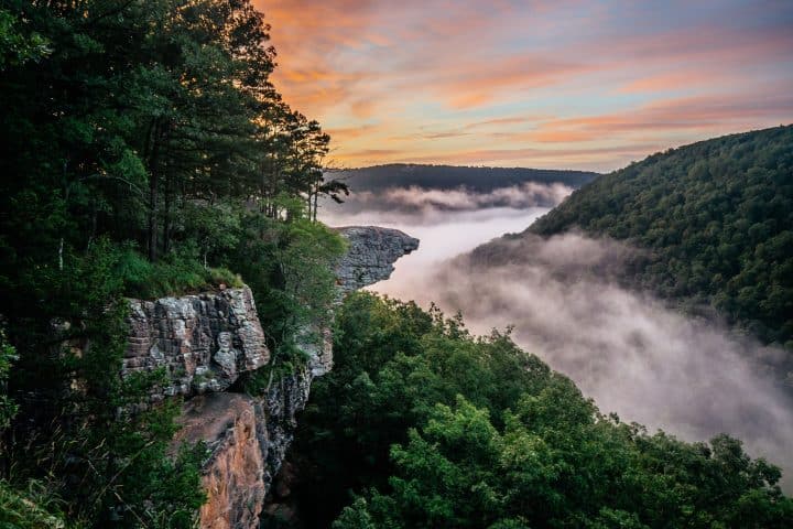
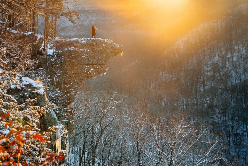
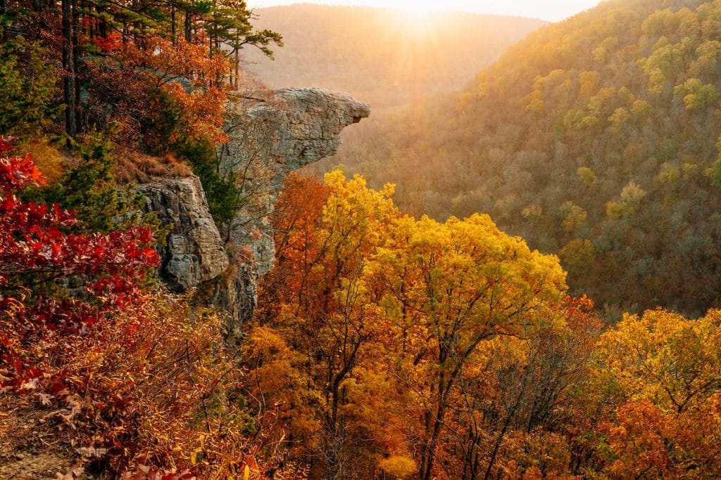
If hikers were pressed to name their top Arkansas hiking trail, Whitaker Point (or, as some call it, Hawksbill Crag) would most likely be the favorite. Located in the Buffalo River headwaters area, Whitaker Point is Arkansas’ most photographed geological feature and with good reason—the crag’s highly scenic wilderness setting is outstanding no matter the season. Winter, spring, summer or fall, anytime is a great time to hike the Whitaker Point trail.
Also, because it is located on National Forest Service land, Whitaker Point is a pet-friendly trail. Thank you for keeping the trail pristine by picking up your pet’s waste during your hike.
Trail Highlights
Outstanding Scenic Beauty
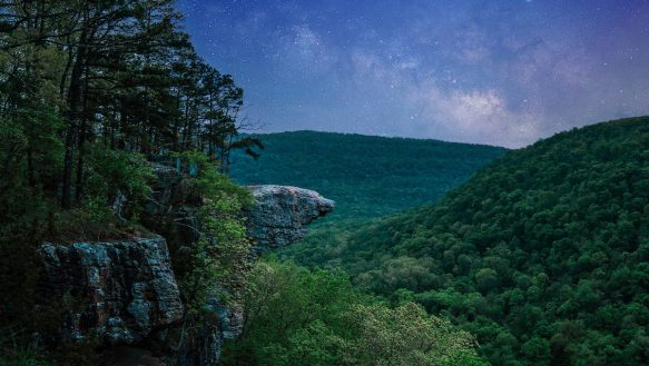
Whitaker Point often takes first-time hikers to the crag by surprise—it’s completely mesmerizing, seeing it hang there in space like it were more cloud than rock. The lofty crag is one of Arkansas’ finest scenic treasures and the trail to it, happily, is one that most any hiker can enjoy.
Romantic Setting
A journalist once placed it in her “Best Places in Arkansas to Get Kissed” travel article. And we can’t begin to count the number of proposals and wedding vows Whitaker Point has been witness to. Perhaps it’s your turn to pledge your everlasting love to someone extra special at the crag? Or, simply sit there on your skyward perch and, together, fall under the magic spell of Whitaker Point’s romantic wilderness setting.
Inspiring Photography
World-class photographers have sought to capture Whitaker Point in the prime of every season. And now, it’s your turn.
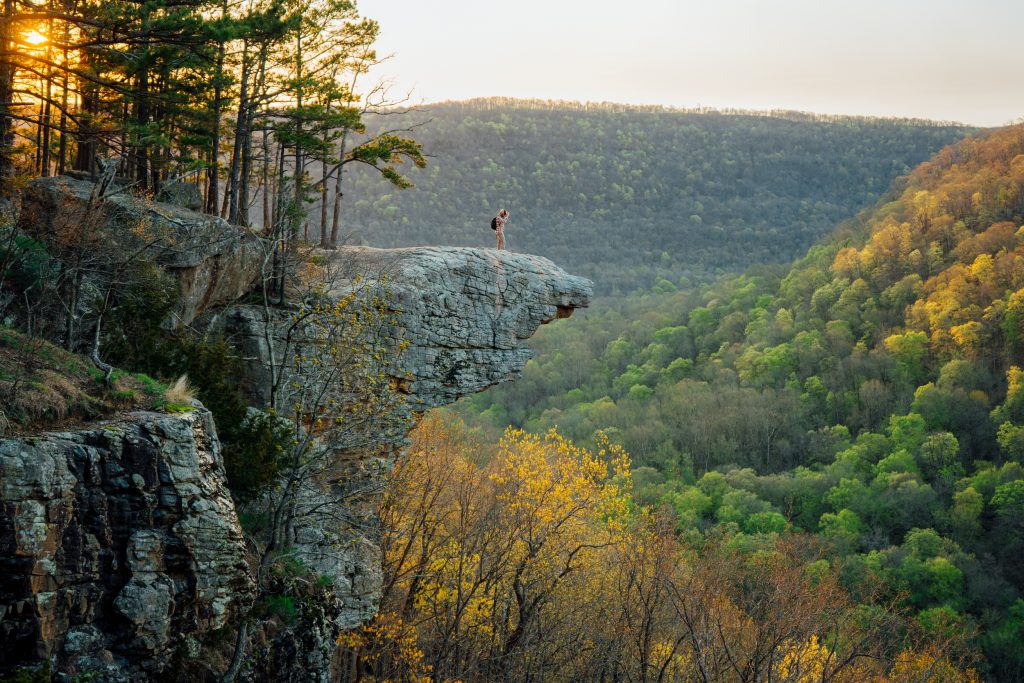
The best time to photograph Whitaker Point / Hawksbill Crag is early in the morning at sunrise or shortly thereafter. Late afternoons are also good once the sun is lower on the horizon. Just be sure and give yourself adequate time to hike back out (generally an hour) with daylight to spare. (Check sunset times online for Ponca or Fallsville, Arkansas for the date you’ll be hiking Whitaker Point.)
A Trail for All Seasons
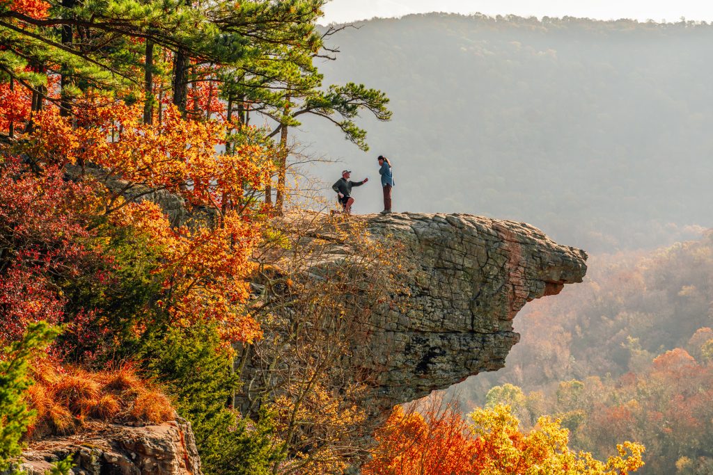
Spring is a glorious time to hike and photograph Whitaker Point as the bright lime greens of newly-emerged tree leaves grace the landscape and wildflowers dot the creek and pour-off areas along the trail. In summer, the shaded trail is still a pleasant hike and the long hours of daylight extend your ability to linger at the crag until early evening. In the fall, the Whitaker Point trail is aglow with the bright oranges and reds of turning maple leaves and other hardwood trees, making the scene a photographer’s dream shot.
Waterfalls & Wildflowers
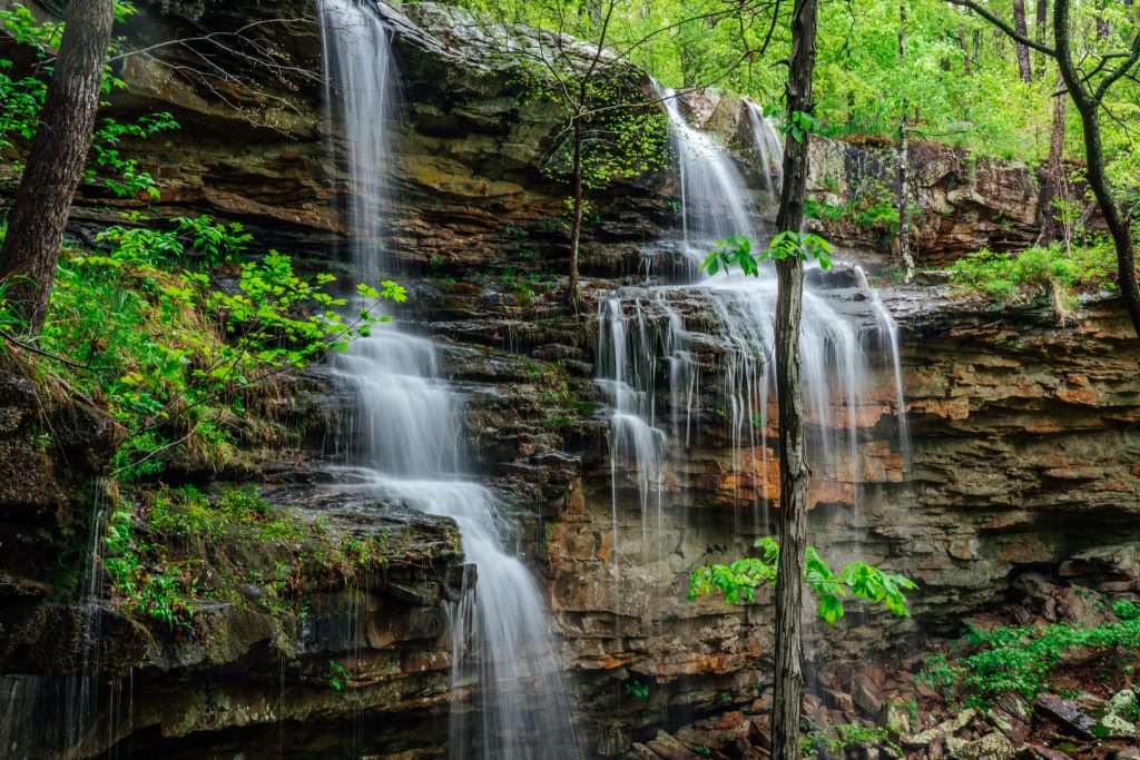
While the craggy rock may be your ultimate destination, there’s plenty to enjoy along the way. About half-way to Whitaker Point you’ll cross a wet-weather creek where you can choose to go straight ahead or turn right, either of which direction will take you to the crag.
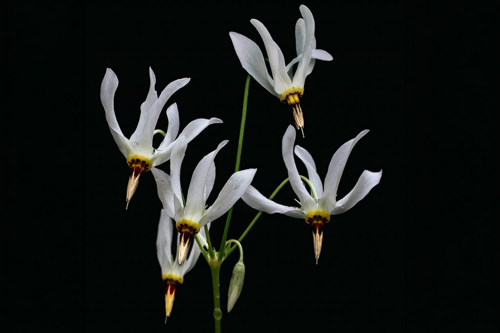
Many hikers choose the right-hand fork, where the trail follows the creek for a bit, ending at a waterfall pour-off ledge. In April and May, watch for Ozark wildflowers like shooting star and fire-pink in bloom along the creek and bluffline, as well as cotton candy-colored mountain azaleas and creamy umbrella magnolia tree blossoms.
At the waterfall pour-off, the trail turns left and follows the bluffline all the way to the crag. Here you’ll find large boulders along the path, places that beg you to sit and drink in the view, even though your final destination is still about 1/3-mile ahead of you. There’s no mistaking you’ve arrived Whitaker Point once it comes into view. Take a few moments to pause and appreciate its grandeur at a distance before completing your hike and finally stepping out onto the crag.
Pack a Lunch and Linger
This is a good trail to pack a couple of bottled waters per person, as folks tend to linger along the way and at the crag. A hearty snack is also in order. Need lunch for the trail? Let the BOC deli pack you a hearty sack lunch to go!
A Wise Word of Caution
Please be extra careful when hiking the Whitaker Point Trail and standing on the crag. A bluffline is a beautiful thing, but also a dangerous one. We cannot stress enough the importance of remaining cautious and staying back from sheer drop offs, as well as keeping a vigilant eye on children, even teenagers.
Trail Map
View the Whitaker Point Trail Map.
What to Expect
Trail Difficulty: Mostly moderate with a few short, somewhat steep sections. On the way out, take a breather or two on the final ¼-mile uphill switchback to the trailhead.
Trail Length: Approximately 3 miles roundtrip
Hiking Time: Set aside 2 or 3 hours for your Whitaker Point hiking adventure. Roundtrip trail time can depend on a variety of factors, including the number of people in your party, your normal hiking pace, how much time you want to linger along the way, presence of children or pets, etc.
What to Pack: Plenty of water and hearty snacks are essential / Trail map / Sunscreen and bug spray / Camera / Small first-aid kit / Cell phone with emergency satellite messaging or other means of contacting 911 such as an InReach device / Rain gear depending on the forecast / Hat for sun protection / Gallon ziplock bag for packing out trash / Headlamp or flashlight if hiking before sunrise or early evening
Cell Service: There is no cell service at Whitaker Point or along the trail.
Parking: Park in one of the designated trailhead parking lots. Cars parked along the road may be ticketed by Newton County’s Finest for obstructing traffic.
Directions
Where is Whitaker Point located?
Whitaker Point (or Hawksbill Crag) is located in the St. Francis National Forest in the headwaters area of the Buffalo National River. The Whitaker Point Trailhead is about about 13 miles south of Ponca or about a 25-minute drive.
Ponca, the closest town to Whitaker Point, is where you’ll find supplies and food for your hiking adventure, including hearty sack lunches made fresh in the BOC Deli and a nice variety of quality to-go snacks and beverages.
WHITAKER POINT TRAILHEAD GPS COORDS: (35.8984206, -93.4578680)
Please note GPS coords are approximate, give or take a few yards.
Directions to Whitaker Point / Hawksbill Crag from Ponca, AR
From Ponca, take Hwy 43 South to Hwy 21. Turn left. Go about two miles to the Boxley Bridge that crosses the Buffalo National River. Turn right onto gravel road #9560 (referred to on Google Maps as Co Rd 5) and go about 6 miles. Cave Mountain Church & Cemetery on the right is an indicator that the parking lots for Whitaker Point and the trailhead itself are only about 1/2-mile ahead of you. Parking is available on both sides of the road: the first parking lot is on the left just before you arrive the trailhead with the second parking lot being on the right directly across from the trailhead.
Directions to Whitaker Point / Hawksbill Crag from Kingston, AR
If you are coming from Highway 21 at Kingston to Whitaker Point (and aren’t coming into Ponca), leave the the Kingston square and follow Hwy 21 for about 11 miles to the bridge that crosses the Buffalo National River. Don’t cross the bridge. Instead, turn right onto CR #9560 (referred to on Google Maps as Co Rd 5) and go about 6 miles. Cave Mountain Church & Cemetery on the right is an indicator that the parking lots for Whitaker Point and the trailhead itself are only about 1/2-mile ahead of you. Parking is available on both sides of the road: the first parking lot is on the left just before you arrive the trailhead with the second parking lot being on the right directly across from the trailhead.
Directions to Whitaker Point / Hawksbill Crag from Little Rock, AR
Take I-40 from Little Rock toward Clarksville, where just before Clarksville you’ll take the Lamar Exit (AR Hwy 64). Continue to the small town of Lamar and on to the north side of Clarksville, watching for the Hwy 21 & Hwy 64 junction just past the Clarksville airport about ½ a mile. At this junction turn right onto Hwy 21 and begin to follow highway directional signs to the Boxley Valley. It’s about an hour or so from the turn onto Hwy 21 to the Boxley Valley (approx. 40 miles) and the small bridge that crosses the Buffalo National River. Cross the bridge and immediately turn left onto CR #9560 (referred to on Google Maps as Co Rd 5). You’ll now drive about 6 miles to the trailhead. Cave Mountain Church & Cemetery on the right is an indicator that the parking lots for Whitaker Point and the trailhead itself are only about 1/2-mile ahead of you. Parking is available on both sides of the road: the first parking lot is on the left just before you arrive the trailhead with the second parking lot being on the right directly across from the trailhead.


